The West Houston Archives
Discover the history of West Houston from its many roads
BARKER-CYPRESS RD.
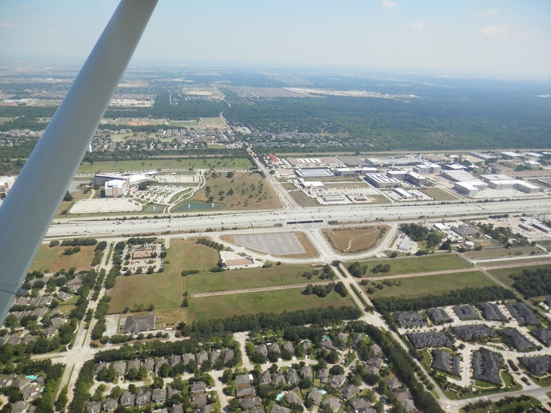
(Above photo: Aerial view of Barker Cypress Rd., facing north from the intersection with I-10/Katy Freeway, August 2013)
Barker-Cypress Rd. runs north and south between the towns of, yes that's right, Barker and Cypress; two railroad towns that were active in the turn of the 20th century. However the present-day route of Barker-Cypress Rd. is somewhat different from the original. At the end of the 1970's, the original Barker-Cypress route was simplified by adding a bypass segment through the woods that would eliminate a whole bunch of doglegs and left/right turns. The bypassed parts of the original Barker-Cypress became known as Saums, Greenhouse, Old Greenhouse, and Gummert.
In Cypress, the road originally came to intersect with Hempstead Rd, and continued no further north. After the extension of the 290 freeway into and beyond Cypress, Barker-Cypress Rd. was extended further north, serving many newer residential and commercial developments.
For me as a child growing up in Copperfield, Barker-Cypress Rd. represented the edge of the world. My family didn't often drive that far west for any reason, and my friends and I would occasionally ride our bikes along Longenbaugh until we hit Barker-Cypress and turn around. It was just two lanes surrounded by nothing but tall grass and random houses. Some time around the end of the 20th century, Barker-Cypress was widened, and had one sharp curve smoothed out between West Rd. and 290. After that, neighborhoods like Riata Ranch began popping up alongside the street, and soon, businesses followed. Now, Barker-Cypress is growing rapidly, similar to the way Highway 6 did.
I wish I had the foresight to have gotten some photographs of Barker-Cypress before it began growing, but I only began taking notice around 2005. I have posted everything I could find in my photo archives of Barker-Cypress.
MARCH 2005
Album 19 Pic 04.jpg : Berry Stadium under construction, March 2005.
Album 19 Pic 01.jpg : Facing north along Barker-Cypress from CVS Pharmacy at West Rd., March 2005.
Album 19 Pic 02.jpg : Berry Stadium under construction, March 2005.
2006
Album 19 Pic 05.jpg : Berry Stadium in final stages of construction, some time in 2006.
Album 19 Pic 06.jpg : Berry Stadium, complete, 2006.
2009
BCYR 009.jpg : Traveling east along 290 freeway passing beneath Barker-Cypress overpass, 2009.
FEBRUARY 2013
Feb 2013a 040.jpg : Reconstructing the access lanes at 290 and Barker-Cypress, Feb. 2013.
Feb 2013a 041.jpg : Reconstructing the access lanes at 290 and Barker-Cypress, Feb. 2013.
Feb 2013a 042.jpg : Reconstructing the access lanes at 290 and Barker-Cypress, Feb. 2013.
OCTOBER 2013
Oct 2013 034.jpg : Aerial view facing south along Barker Cypress corridor from Towne Lake community, Oct. 2013.
Oct 2013 035.jpg : Another aerial view facing south along Barker-Cypress from Towne Lake area, Oct. 2013.
Oct 2013 052.jpg : Aerial view of Barker-Cypress and Tuckerton Rd. intersection, Oct. 2013.
Oct 2013 053.jpg : Aerial view of the newly completed access ramps at 290 and Barker-Cypress, Oct. 2013.
Oct 2013 028.jpg : Another aerial view of the 290/ Barker-Cypress intersection, Oct. 2013.
Oct 2013 050.jpg : Aerial view of Langham Creek High School at Barker-Cypress and FM 529, Oct. 2013.
JUNE 2014
Jun 2014a 013.JPG : A view of the original Barker-Cypress overpass at 290 in June 2014 when they began demolishing the original bridge during the summer months.
Jun 2014a 088.JPG : Traffic backed up on Barker-Cypress approaching 290 from the south with half the bridge demolished, June 2014.
Jun 2014a 089.JPG : Entering the 290 frontage road from the original Barker-Cypress overpass, June 2014.
JANUARY 2015
Jan 2015a 047.jpg : Barker-Cypress directly across from Lone Star College near West Rd., a newly built Whataburger and in the distance, Popeye's Chicken.
Jan 2015a 048.jpg : Barker-Cypress directly across from Lone Star College near West Rd. a new building under construction beside Whataburger.
Jan 2015a 049.jpg : Barker-Cypress directly across from Lone Star College near West Rd., facing the Express Oil Change shop.
MAY 2015
May 2015a 051.JPG : A view south along Barker-Cypress from the intersection with 290.
May 2015a 099.JPG : On top of the Barker-Cypress overpass facing east along 290.
OCTOBER 2015
Oct 2015a 056.JPG : The new Towne Lake shopping center under construction at Barker-Cypress & Tuckerton.
Oct 2015a 058.JPG : The new Towne Lake shopping center.
Oct 2015a 060.JPG : The new Towne Lake shopping center.
Oct 2015a 061.JPG : The Towne Lake Marina next to the shopping center.
Oct 2015a 062.JPG : A view of Tuckerton Rd. running through Towne Lake area. The bridge structure near Barker-Cypress has now been made into a pair of bridges.
Oct 2015a 063.JPG : Another photo of the Towne Lake Marina.
MARCH 2016
Mar 2016a 036.JPG : This Randall's at the corner of Barker-Cypress and Clay Rd. originally opened as an Albertson's grocery chain around 1999.
Mar 2016a 037.JPG : Close up of the Randall's/Albertson's entrance.
APRIL 2016
Apr 2016a 025.jpg : Aerial photo of Barker-Cypress Rd. at I-10, facing north. Notice the curved access road on the south side of Barker-Cypress. This was part of the original intersection design in which I-10 stayed at ground level, and Barker-Cypress passed over it (similar to the present-day intersection of Barker-Cypress with 290). This configuration was changed during the I-10 overhaul from 2006-2008.
________________________________________________________________________________________________________________________________________________________________________________________________________________________________